6. Carta del Cantino, 1502
Carta del Cantino, 1502. Estensi Digital Library, Biblioteca Estense Universitaria, Modena, Italy. Permission pending from the the Ministry of Cultural Heritage and Activities, Italy.
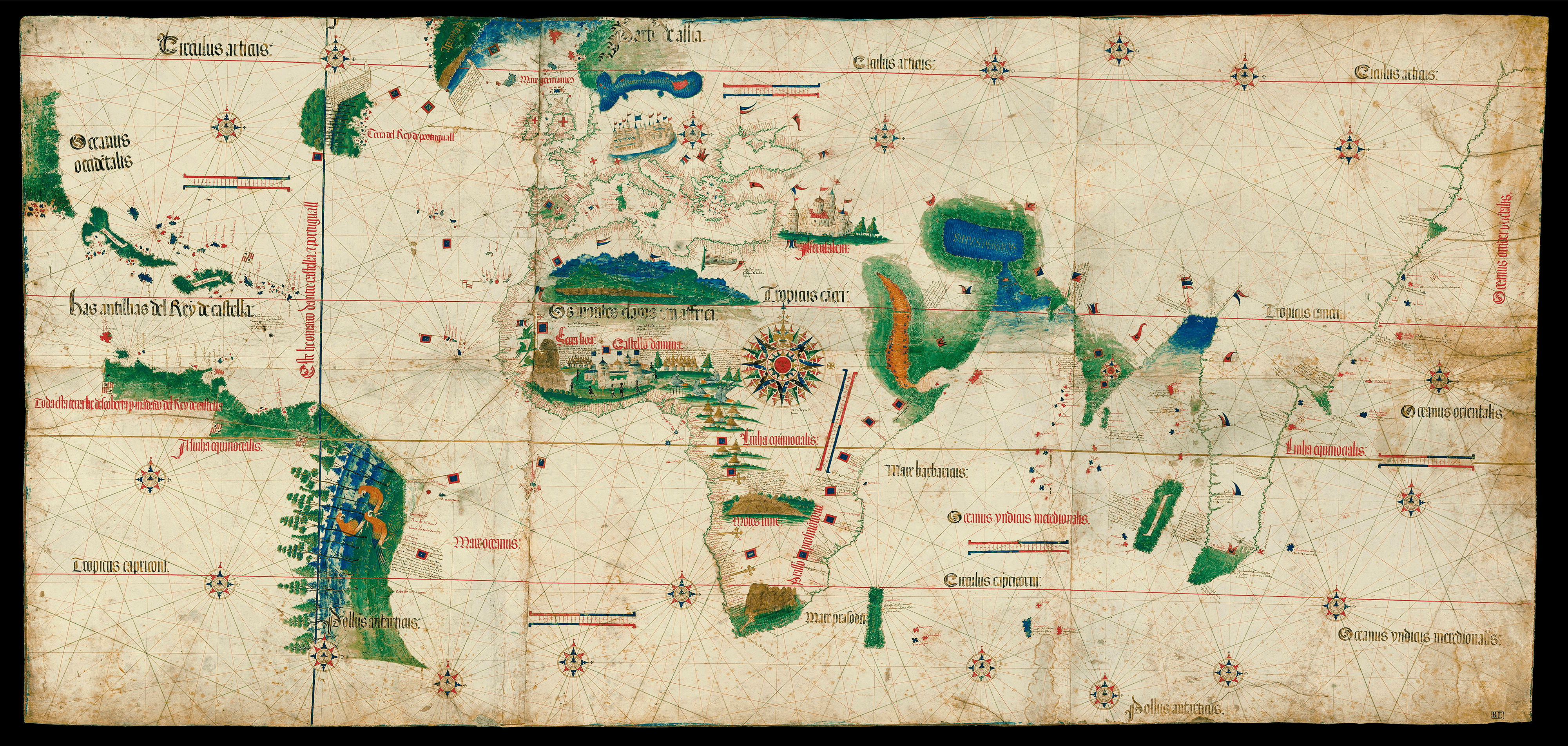
Carta del Cantino presents a spectacular new view of the world. Joaquim Alves Gaspar calls it “one of the most important monuments in Europe’s cartographic heritage” because of the way that it “showed a different world from the traditional Ptolemaic representation.” The Indian Ocean “takes a new form,” and the lands previously unknown to Europeans, such as Newfoundland and Brazil, “are depicted in their correct geographic locations.”* The Atlantic occupies a fundamental and expansive place. The Atlantic Ocean is labeled as the “Oceanus Occide[n]talis” (Western Ocean) in the North and the “Mare Oceanus” (Ocean Sea) in the South. The oceanic space separating Europe and Africa in the East from the newly encountered lands in the West takes up nearly one-third of the world. The Mediterranean and Black Seas are small and landlocked. The Indian Ocean (Oceanus yndias meridionalis) is connected to the Atlantic and has its own coherence, which is linking Africa, India, and Southeast Asia. The Pacific, although not yet named, has a separate identity–the Oceanus Orientalis (Eastern Ocean). From the central compass rose radiate rhumb lines, but as discussed in Fig. 3.2, the world chart is constructed around two center points: one in Cape Verde and the other in India. Hundreds of toponyms are lettered in, flags mark the realms of kings, and texts written in Portuguese describe lucrative trading opportunities. This representation of the world with the Atlantic occupying the center left would dominate the presentation of the world for centuries to come. I argue that the anonymous chartmaker of Carta del Cantino is Pedro Reinel, see “Who Cares Who Made the Map,” e-perimetron 12 (201): 1-23. This world chart is part of the collection of the Biblioteca Estense Universitaria, in Modena Italy. To consult it in the Gallerie Estense, click here.
* (2012) Blunders, Errors and Entanglements: Scrutinizing the Cantino Planisphere with a Cartometric Eye, Imago Mundi, 64 (2012): 181-200.