Fig. 1.7. The Atlantic on the World Map by Henricus Martellus
Henricus Martellus Germanus, Mappamundi, Insularium Illustratum, ca. 1490-95 The British Library, London.
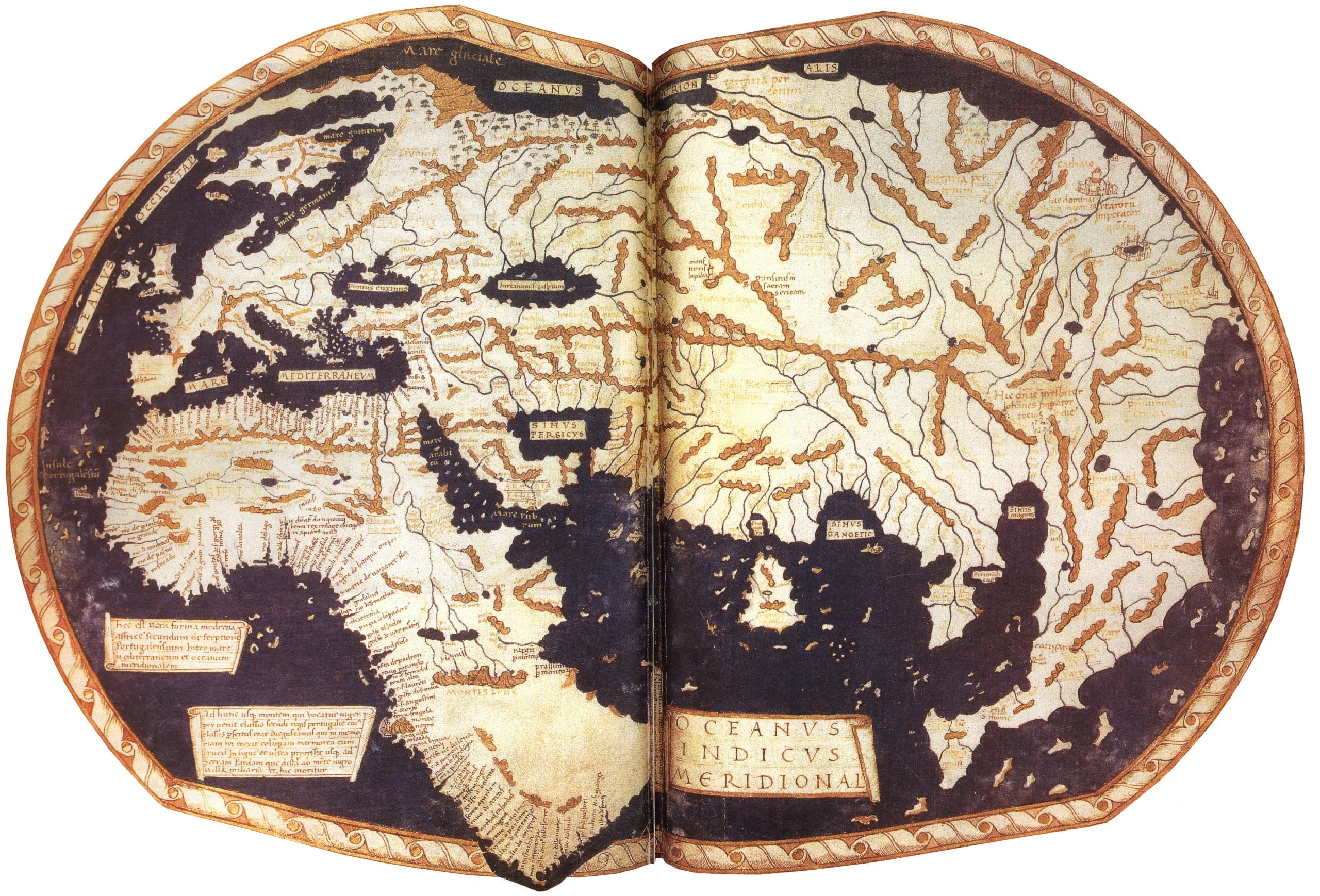
Henricus Martellus Germanus, a German artist and mapmaker living in Florence in the second half of the fifteenth century, began to modify the usual representation of the Atlantic Ocean found on mappaemundi drawn from Ptolemy’s instructions. Martellus created two very distinctive maps, both before Columbus’ voyage in 1492, that present the Atlantic as a far more expansive oceanic space. One, above, appears in an illuminated manuscript, titled the Insularium Illustratum. This was an illustrated atlas of islands, and Martellus copied it from Cristoforo Buondelmonti, who had created illustrated itineraries of his travels through the Greek Islands in the early fifteenth century. Martellus made several copies of the Insularium Illustratum, most likely for patrons. Originally copying the manuscript closely, but later adding new maps and changing the text, one can see how Martellus began to add information to Ptolemy’s world map. In several of the surviving versions of the Insularium Illustratum, Martellus included a mappamundi, one of which has fascinated historians of cartography for centuries. The mappamundi appears in the British Library edition of Martellus’s Insularium Illustratum, which is ca. 1490-95. On this mappamundi, Martellus departs from the usual depiction of the coastline of west Africa in order to include Bartolomeu Dias’s voyage of 1488. On this voyage, Bartolomeu Dias sailed along the entire coast of West Africa, rounded the Cape of Good Hope, and reached Rio do Infante (today Great Fish River), before returning to Lisbon. Apparently, Martellus had access to these charts, or copies of them, for Martellus maps the western coastline of Africa, from Gibraltar to the Cape of Good Hope, and he shows the beginnings of the Indian Ocean coastline of southeast Africa. Note how he breaks the border on the bottom of the map in order to show that Africa can be circumnavigated. Moreover, his placement of the scroll labeled Oceanus Indicus Meridional (Southern Indian Ocean) draws the eye of the viewer to this section of the map. The two prominent legends placed in the south Atlantic, off the coast of Africa, convey Martellus’ argument that his map shows the “true shape of Africa” and the importance of the Portuguese voyages along the coast of south central Africa. Martellus’ other striking world map is the Map of the world of Christopher Columbus at the Beinecke Library, Yale University.
Access to the complete edition of